


Annapurna, Nepal
Nepal
14 Days
Challenging
Trekking/ Hiking
5416 M / 17769 Feet
Mar to May, Sep to Nov
Included
Kathmandu/ Kathmandu
Hotels and Teahouses
The Annapurna Circuit Trek is a much longer and more thorough trek than the Annapurna Base Camp (ABC) Trek. While the main goal of ABC trek is to reach the Annapurna Base Camp, the Annapurna Circuit is about exploring the regions in and around Annapurna. Spanning from subtropical lowlands to the arid highlands near the Tibetan plateau, this trek moves through an astonishing variety of terrains.
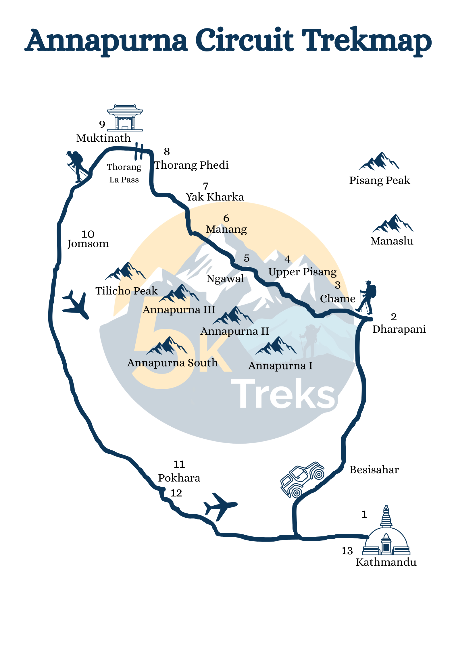
You trek begins with a long drive from Kathmandu to Dharapani via Besisahar. It takes about 8 hours. The path follows the Marshyangdi River, winding through valleys lined with rice terraces, lush forests, and scattered villages. The river, a constant companion, cuts through the land with an unyielding force, and as you move along its banks, you’ll notice the shifting character of the terrain. Early on, the landscape feels densely vegetated, with thick forest and cascading waterfalls. As the trek progresses, the path climbs steadily into higher altitudes. The once lush terrain begins to thin out, giving way to drier forests and wide, open spaces. The atmosphere becomes increasingly remote. The people here are a mix of Gurung, Magar, and Tibetan-influenced ethnic groups. Manang village, a significant stop on this trek, is the biggest and most populated village around this region. The place is significant for cultural as well as historical reasons. Milarepa, the most famous Tibetan sorcerer, meditated in a cave nearby. It is now called the Milarepa Cave, and is at a short distance from Manang. After spending a night at Manang, you will trek to Yak Kharka and then to Thorong Phedi, the base for the high-altitude crossing of Thorong La Pass (5416 meters), a formidable and striking point on the route. This pass is physically challenging, but the staggering views along the way more than makes up for it. Therefore, the previous day will be spent at Manang resting and acclimatizing—preparing you for the tough journey ahead. The views along the way are staggering to say the least.
On your descent, you enter the Mustang region, where the landscape shifts dramatically from green valleys to the stark beauty of arid, wind-swept hillsides, reminiscent of Tibetan highlands. After crossing Thorong La and descending into the dry, open expanse of Mustang, you will eventually reach the Muktinath Temple, a sacred site that draws pilgrims from across the region. The temple here, dedicated to both Hindu and Buddhist traditions, feels like a timeless place where spiritual significance blends with the surroundings. The stark desert-like landscape, punctuated by vibrant prayer flags and shrines, serves as a poignant reminder of the cultural synthesis between Hinduism and Buddhism in this region. The route then continues through Jomsom, a hub in the region known for its wide, barren plains and the wind that howls through the valley. From Jomsom, you can either trek or fly to Pokhara. You can spend an extra day at Pokhara resting or catching up on activities you might have missed on your way up.
Note: You can choose to drive or to fly from Kathmandu to Pokhara and from Pokhara to Kathmandu.
Arrive at Tribhuvan International Airport, Kathmandu; transfer to hotel
Drive to Dharapani via Besisahar [8 hours]
Trek to Chame (2670m) [6 hours ]
Trek to Upper Pisang (3300m) [6 hours]
Trek from Pisang to Ngawal (3660m) [5 hours]
Trek to Manang (3540m) [4 Hours]
Trek to Yak Kharka (4050m ) [6 Hours ]
Trek to Thorong Phedi (4450 m) [4 hours]
Trek to Muktinath (3760m) via Thorong La Pass (5416m) [10 hours]
Trek to Jomsom (2743m) [6 hours]
Fly to Pokhara [20 minutes]
Rest day at Pokhara
Fly to Kathmandu [30 minutes]
Fly to your destination
Best Time for Annapurna Circuit Trek
Aim for autumn (September-November) and spring (March-May): the pass is usually most stable, with clearer skies and excellent visibility. Winter brings very cold, windy mornings at Thorong La and a higher chance of snow/ice; monsoon (Jun–Aug) means wetter, cloudier lower trails and occasional landslides. If you’re targeting fewer crowds, late Nov or late Apr can be sweet spots with cooler nights.
Distance and Days
Total distance varies with start/end and whether you add jeep/flight shortcuts or extensions: expect roughly 160-239 km over 12-18 days; our plan is 14 days with a flight out of Jomson. Classic versions via Tatopani-Ghorepani to Nayapul push the distance and add 3-5 trekking days.
Permits for Annapurna Circuit Trek
Foreign trekkers need an ACAP( Annapurna Conservation Area Permit) + TIMS; since March/April 2023, a licensed guide and agency-issued TIMS are mandatory on most protected-area routes (including Annapurna). ACAP can be obtained online; current posted fees: NPR 3,000 (foreign)/ NPR 1,000 (SAARC) plus 2.9% gateway fee; double fees if you buy at a check-post. We handle all paperwork and carry printed/e-copies. (fees/policies may change; we reconfirm during booking)
Bags & weight
Pack a duffel bag, 10-12 kg, for the porter and a daypack, 5-7 kg, for water, layers, and camera. Ethical load for one porter is commonly kept near 20-24 kg total across 1-2 trekkers; we add porters if needed so nobody’s overloaded. If you fly from Jomson to Pokhara, mountain routes typically allow 10 kg checked + 5kg hand; we’ll weigh bags the night before.
Insurance
Buy trekking insurance that explicitly covers helicopter evacuation and high altitude (ideally up to 6,000 m). Check that emergency search & rescue and medical are included, plus trip interruption for weather-related delays (Jomsom flights). Keep the insurer’s 24/7 assistance number handy; most providers require you/your guide to call before any heli is dispatched.
Power & Wi-Fi
Expect patchy power and internet as you go higher. Lodges usually charge a small fee for charging and Wi-Fi above Manang, and sockets can be limited at peak times. Bring a 10,000–20,000 mAh power bank, spare cables, and download offline maps (Maps.me/Gaia) before you leave Pokhara/Kathmandu.
Water
Refill at lodges/taps and treat every liter (chlorine-dioxide tabs or a filter + UV pen). Hot drinks and boiled water cost extra at altitude, so budget a little daily. Avoid single-use plastic where possible—carry two 1-liter bottles or a 2–3 L bladder and top up at lunch and camp.
Difficulty
Overall grade: moderate–challenging. Trails are non-technical, but the pass day to 5,416 m is long and exposed. A comfortable week of pre-trip hiking, plus steady ascent, hydration, and a real acclimatization day in Manang, makes the biggest difference. We monitor symptoms daily and adjust pace, overnights, or add a buffer day if conditions dictate. Thorong La Pass (5,416 m/17,759 ft) above sea level is the peak point, where altitude sickness is a significant risk. Being physically fit, properly acclimatized, and mentally prepared are crucial for this trek.
+
+
+
+
+
+
$1575.00
© 2026 5k Treks Pvt. Ltd. All rights reserved.
