

2026-01-19
4 min read
The Everest Base Camp trek map generally refers to a route map of the Khumbu Valley hike in Nepal, commencing with an airplane landing in Lukla and finishing at the base camp of Everest (5,364m). The majority of trekkers also climb to Kala Patthar (5,644m) to get the best views of Everest.
Key points your trekmap should show:
The following is the popular Everest Base Camp trek map route in clear-cut form (easy to understand by a reader looking to get a simple route confirmation):
Discover: How Far Is Everest From Kathmandu?
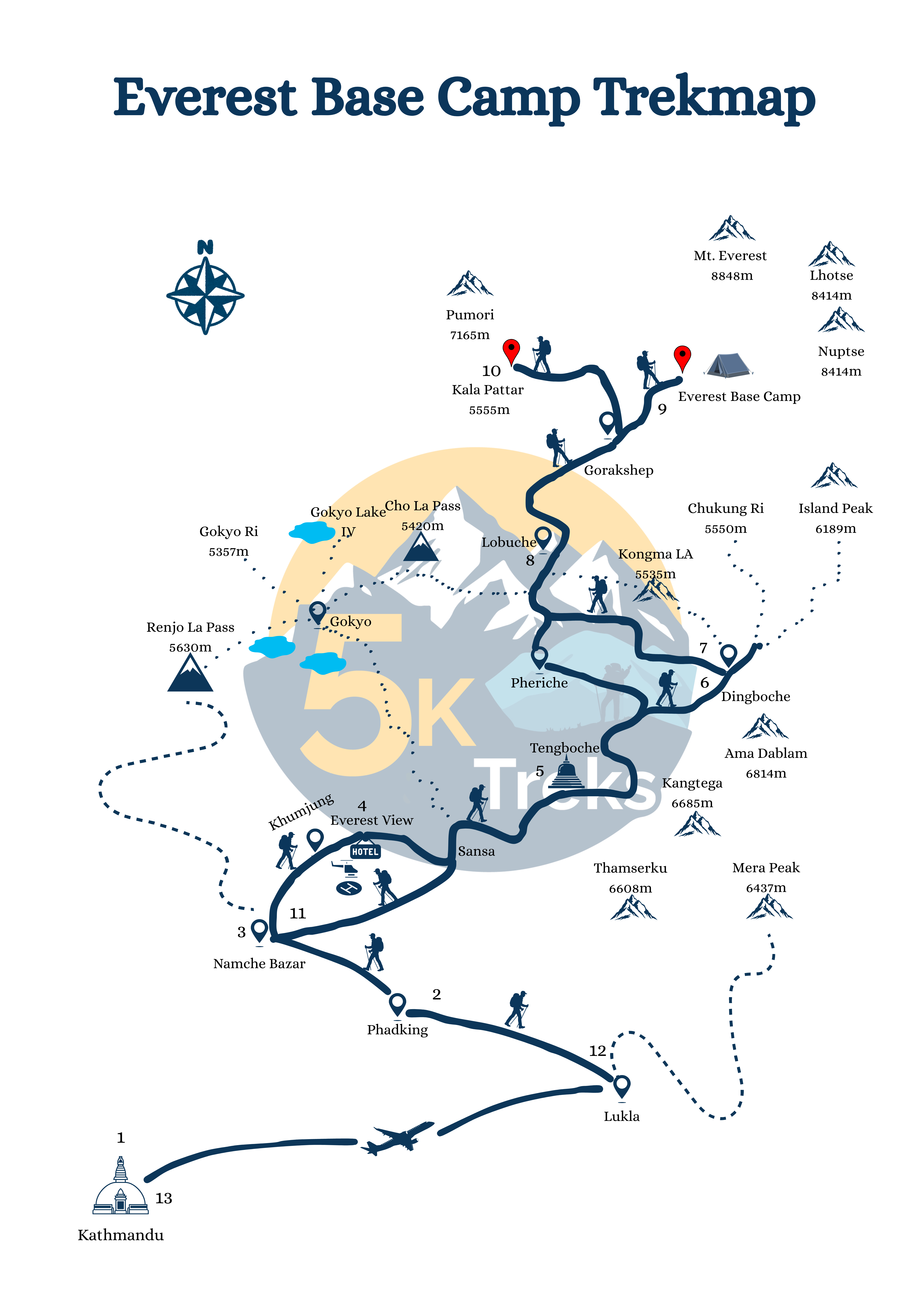
The primary reason people search for an Everest Base Camp trek map is to plan their altitude.
Main altitude milestones
Altitudes are precise; hiking duration and distance vary with the itinerary, side hikes, fitness, and weather.
Below is a standard 12-day EBC trek map stage plan (approximate distances).
Note: Distances are approximate and can vary depending on the exact trail choices and lodge locations.
Day | Route (Stage) | Approx. Distance | Est. Walking Time | Overnight Altitude |
1 | Fly to Lukla → Trek to Phakding | 6–9 km | 3–4 hrs | 2,610m |
2 | Phakding → Namche Bazaar | 9–12 km | 5–7 hrs | 3,440m |
3 | Acclimatization in Namche (hike + return) | 4–8 km | 2–4 hrs | 3,440m |
4 | Namche → Tengboche | 9–12 km | 5–6 hrs | 3,860m |
5 | Tengboche → Dingboche | 10–12 km | 5–7 hrs | 4,410m |
6 | Acclimatization in Dingboche (hike + return) | 4–8 km | 2–4 hrs | 4,410m |
7 | Dingboche → Lobuche | 7–10 km | 5–6 hrs | 4,940m |
8 | Lobuche → Gorak Shep → Everest Base Camp → Gorak Shep | 10–15 km | 7–9 hrs | 5,164m |
9 | Kala Patthar (optional) → Pheriche | 12–16 km | 6–8 hrs | 4,240m |
10 | Pheriche → Namche Bazaar | 14–18 km | 6–8 hrs | 3,440m |
11 | Namche → Lukla | 17–20 km | 6–8 hrs | 2,860m |
12 | Fly out from Lukla | — | — | — |
Many trekkers search for the Everest base camp trek map because they want one they can access even without a mobile signal.
Proposed offline strategy.
Practical offline tips
The most comfortable seasons for most hikers are:
The treks can be done in winter, but it is colder, and the weather can affect flights to Lukla more significantly. During the monsoon, there are more clouds and rain at lower altitudes.
Most trekkers need:
Permit rules can change, so confirm requirements right before your trek.
Altitude is the real challenge, despite a perfect Everest Base Camp trek map.
Sophisticated acclimatization strategies.
Common trekking mistakes
+
+
+
+
© 2026 5k Treks Pvt. Ltd. All rights reserved.
