
2026-05-12
14 min read
If you're considering an Annapurna Circuit Trek in the Himalayas, you cannot underestimate the importance of understanding the elevation profile, as it will determine whether you reach the summit of Thorong La Pass or need to be evacuated early. This guide provides thorough information on all altitude waypoints/landmarks throughout the trek, as well as how your body adapts to each altitude level through the process of acclimatization. Best-practice safety measures, implemented by experts, are in place to protect you from your starting point in Besisahar to your final destination in Pokhara.
With a total elevation gain of over 4,656 meters (15,284 ft), this trek provides some of the highest ascent on any traditional trek anywhere in the world. Beginning at an elevation of around 760 meters (2,493 ft) near the village of Besisahar, you will ascend to the Thorong La Pass at an altitude of 5,416 meters (17,769 ft). The descent from Thorong La is very steep, dropping down to near the elevation of 1,190 meters (3,904 ft) at Tatopani before ascending again to Ghorepani, where you will finish your trek in Pokhara.
No other classic trek in Nepal covers such an extreme and continuous elevation range in a single circuit journey.
Key Annapurna Circuit elevation facts at a glance:
The table below reflects the standard 13–16 day itinerary, which is the recommended pacing for safe acclimatization.
Day | Stage | Elevation |
1 | Besisahar (drive start) | 760 m / 2,493 ft |
2 | Tal | 1,700 m / 5,577 ft |
3 | Dharapani | 1,860 m / 6,102 ft |
4 | Chame | 2,670 m / 8,760 ft |
5 | Upper Pisang | 3,300 m / 10,826 ft |
6 | Manang | 3,540 m / 11,614 ft |
7 | Manang (acclimatization day) | 3,540 m / 11,614 ft |
8 | Yak Kharka | 4,050 m / 13,287 ft |
9 | Thorong Phedi / High Camp | 4,540 m / 14,895 ft |
10 | Thorong La Pass → Muktinath | 5,416 m / 17,769 ft → 3,760 m |
11 | Kagbeni / Jomsom | 2,720 m / 8,924 ft |
12 | Tatopani | 1,190 m / 3,904 ft |
13 | Ghorepani | 2,860 m / 9,383 ft |
14 | Poon Hill → Pokhara | 3,210 m / 10,531 ft → 820 m |
You can hike through the south temperate and the south tropical zones from Besisahar to the Marsyangdi River valley via Tal, Dharapani, and Chame, all of which will provide you with a lot of forested area and a much easier time physically. Most people will not experience symptoms of altitude sickness at this level of elevation.
Developing your muscles (on the ground) for what will happen after you reach a level of 4,500--5,500 m is the main purpose during this time. You should be hiking at least 16–22 km per day, so that your legs will be conditioned for the higher elevations you will experience in the near future. You can also explore, as the air will be heavier, and the teahouses will be warm and welcoming, and altitude-related problems such as altitude sickness shouldn't be an issue as of yet.
When you travel from Chame to Manang, you will see a big change in the landscape. Pine forests will change to an alpine environment, and this is when high altitude awareness begins for trekkers around Pisang. When trekkers get to Upper Pisang at an altitude of 3,300 metres, they may already have started to feel some symptoms from the high altitude, such as breathlessness on uphill climbs, not being able to sleep very well, and/or a slight headache that will go away once they rest.
Manang (3,540 m) is not only the last large village to be reached before the start of the ascent into a critical altitude zone, but it is also the physiologically important resting place for your body to adjust to being at high altitude before climbing into extreme heights.
It is during the ascent from Manang to Thorong La that the Annapurna Circuit elevation profile gets pretty serious. The ascent from Manang to Thorong La of around 1,900 vertical meters over a period of 2-3 days adds significant difficulty to the hike. One can expect to notice lower air density, approximately half the oxygen available at sea level, and a conscious effort to take each step uphill.
The danger level for Acute Mountain Sickness (AMS) starts at 3,000 meters and increases very quickly after reaching 4,000 meters. One's body will be working harder than it ever has to breathe and sleep when you reach Yak Kharka (4,050) and Thorong Phedi (4,540).
From Thorong La (5416m) to Muktinath (3760m) is a descent of such steepness and speed that it is among the most rapid altitude drops experienced in a single day of hiking within the entire Himalayas. You will notice as you descend how quickly your lungs become accustomed to the increasing density of the atmosphere. As you continue down to Jomsom and then finally down to Tatopani, there will be an opportunity for your body to recover for quite a long time before continuing with a gentle ascent to get to Ghorepani/Poon Hill.
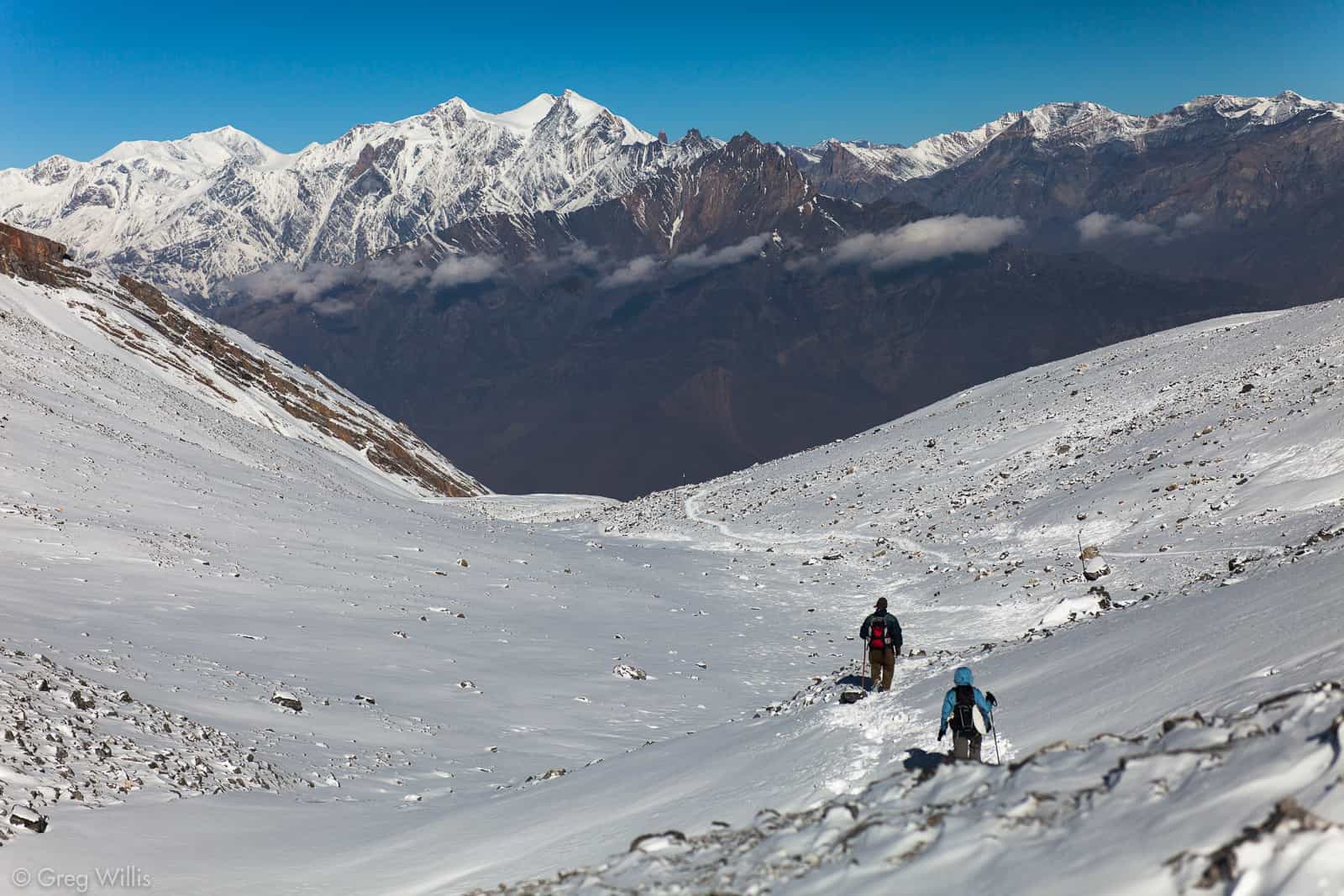
Located at an altitude of 5,416 m (17,769 ft), Thorong La Pass is an absolute highlight on the Annapurna Circuit. At this altitude, the amount of oxygen present in the atmosphere is approximately half that of a typical atmospheric pressure or sea level; therefore, any moderate level of exertion will become quite tiresome very quickly.
It's best to attempt to cross Thorong La as early in the morning as possible. Most guides recommend starting your journey from either Thorong Phedi or High Camp between 3:00 AM and 5:00 AM. The following explains why
Depending on pace and weather, the trek to the Thorong La pass can take anywhere from four to six hours to reach and an additional two to three hours down to Muktinath. With approximately 850 meters gained on the way up and 1,650 gained on the way down, this can be one of the longer and most strenuous days of your journey.
Evidence indicates that 25 to 50% of trekkers who cross the Thorong La suffer from AMS (acute mountain sickness) at some time during their trek. The difference between having a successful trek over Thorong La and needing to be evacuated by helicopter is often based on the quality of your previous days of acclimatization.
As you climb higher, the amount of barometric pressure decreases, and the amount of oxygen a person can get from each breath also decreases. At 4,000 m, around 60% of what is available at sea level will be available to a person at that elevation. By the time you reach Thorong La (the highest point of the trek), which is at 5,416 m, there will only be about 50% of the amount of oxygen available at sea level. For your cardiovascular system and respiratory system to be able to supply enough oxygen to meet the demands of your body and brain, they will have to work significantly harder than they do at sea level.
The body then begins to adapt itself through acclimatization. This process includes increasing breathing rates, developing more red blood cells, and adjusting the cardiovascular system to provide the body with oxygen more efficiently. This process takes time; you cannot hurry along with acclimatization.
According to the Wilderness Medical Society (WMS), if you are at an altitude greater than 3,000 metres, you should limit your elevation gain during sleep for a day to a maximum of 300 to 500 metres above your previous level of sleep. This rule refers to your sleep altitude only - you may hike up in altitude during the daytime if you return to bed at a lower altitude.
The "climb high, sleep low" principle is one of the most effective methods of acclimatizing to high altitudes and, as such, the Annapurna Circuit itinerary has been developed around its use.
Manang is the best way to acclimatize to high altitude. All of the well-respected trekking guides, all of the wilderness medicine guides, and all experienced guides to the Himalayas agree that the rest day at Manang must not be skipped.
Starting from Manang, you will have climbed into the extreme altitude zone (above 3,500m). Your body needs to rest at this elevation to solidify the acclimatization process that it has been developing since Besisahar. One rest day is the minimum; two rest days are best if you have no experience trekking above 3,000m.
You should do an active acclimatization hike for your Manang rest day instead of doing passive rest. The best way to do this is by hiking to Ice Lake (4,600m elevation), which will take you 1,100m higher than your sleeping elevation, and return to Manang for your overnight accommodation. This is better than doing nothing at Manang because it encourages the body to produce more red blood cells during the rest period, versus resting at a stationary position. Alternatively, Gangapurna Lake (3,900m elevation) is a shorter option.
It is possible for the trekkers to extend their stay in Thorong Phedi/High Camp before crossing the pass by one night. Although this extra night will not be needed by the majority of the trekkers who have a normal pace of walking and do not have significant issues while at Yak Kharka, it certainly will benefit people who have had potential signs of altitude sickness at Yak Kharka and for first-time trekkers above the altitude of 4,000m.
One of the most frequently experienced ailments when trekking the Annapurna Circuit is acute mountain sickness (AMS). Symptoms usually present themselves within 6-12 hours of arriving at a higher elevation and may include: headache, nausea, fatigue, dizziness, and lack of sleep. A considerable number of trekkers will be affected by AMS once they have exceeded 3,500 meters.
A severe progression of AMS involving swelling of the brain. Symptoms include confusion, loss of coordination, and altered consciousness. HACE is a medical emergency requiring immediate descent.
Fluid accumulation in the lungs. Symptoms include shortness of breath at rest, persistent cough, and chest tightness. HAPE is also a medical emergency and is the most common cause of altitude-related death in trekkers.
HACE and HAPE are rare but escalate rapidly. Do not wait to see if symptoms improve on their own — descend immediately and seek medical assistance.
The only way to effectively treat high-elevation sickness and its associated symptoms is by descending. An average of three hundred to five hundred meters of descending produces an almost instant cure for many hangover problems. If a person at an altitude of four thousand meters chooses to go higher with worsening symptoms, it can be one of the worst things they can do. It is not wise on a remote Himalayan trail to disregard what your body is trying to tell you.
Ascend gradually from the start. Begin trekking from Tal or even Besisahar rather than driving to Chame or Pisang. The lower elevation stages are not boring, but they are a physiological preparation.
Elevation | Zone | Physiological Effects |
Up to 2,500 m | Low altitude | No significant effects for most people |
2,500 – 3,500 m | Moderate altitude | First signs of reduced oxygen, mild breathlessness on exertion, possible |
3,500 – 5,500 m | High altitude | Serious AMS risk; acclimatization critical; oxygen ~50–65% of sea level |
Above 5,500 m | Extreme altitude | Physiological deterioration regardless of acclimatization time |
Thorong La Pass at 5,416 m sits at the upper boundary of the high-altitude zone — close enough to extreme altitude that every acclimatization decision in the preceding days has direct consequences on your ability to cross it safely.
Both trekking paths are considered by several trekkers. Each route has a very different elevation profile.
The Annapurna Base Camp trek (ABC) has its highest point at an altitude of 4,130 m (13,550 ft). The ascent is completed slowly over four to five days, allowing ample time for the body to achieve an adequate level of acclimatization. While some trekkers may experience Acute Mountain Sickness (AMS) while trekking ABC, most fit trekkers with limited experience in trekking in the Himalayas can prepare for an enjoyable trekking experience in the Annapurna Region.
The Annapurna Circuit trek has its highest point at an altitude of 5,416 m. Once climbers have reached a starting point at Manang (3,540 m), they will be trekking to the summit of the pass in just two days, with a total elevation change of 1,876 m - that is significant since it occurs in a danger zone for developing AMS.
Both trekking routes that are being considered can be completed; however, the trekking route that includes the Annapurna Circuit is more difficult. The trekkers who intend to traverse the Annapurna Circuit will need to take into account the type of elevation profile they will be encountering and should plan appropriately for the conditions.
The Annapurna Circuit Trek has a one-of-a-kind elevation profile that is unlike anything else on earth, but it will not be kind to those who try to take shortcuts. When gaining any amount of elevation above 3,000 metres, your body must respect a pace that allows you to adapt to the new elevation. Trekkers who successfully cross the Thorong La Pass generally do so with no difficulties or issues. This is almost always due to trekkers being prepared by following a gradual itinerary, resting in Manang, starting early, and listening to what their bodies are saying to them.
The view at 5,416 metres is a view that is earned, as opposed to simply being given to you. The stunning views of the Annapurna and Dhaulagiri mountain ranges, with prayer flags whipping in the wind, are well worth the preparation and gradual ascent required when hiking the Annapurna Circuit.
+
+
+
+
+
+
+
© 2026 5k Treks Pvt. Ltd. All rights reserved.
